LONDON, Ont. — A research group that collaborates with Environment Canada to find and document tornadoes has confirmed that a remote area of Northwestern Ontario experienced the province's first tornado of 2020.
It happened on June 8 near Brooks Lake, approximately 35 kilometres northeast of Nestor Falls.
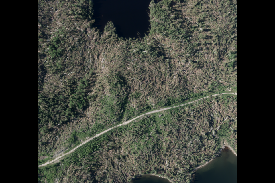
David Sills, executive director of the Northern Tornadoes Project at Western University in London, says aerial images have allowed his team to confirm the damage to the forest in that area was caused by an EF 2 tornado.
That means the wind speed during the event reached three-second gusts between 179 and 217 kilometres an hour (111 to 135 miles an hour).
Tornadoes are rated on a scale from EF 0 to EF 5.
"We knew that there were big storms that moved through that area, including supercell storms that tend to produce strong and even violent tornadoes," Sills told tbnewswatch.com.
"So we were looking along those storm tracks to see if we could find any damage. Once the satellite data became available after the fact, we started seeing evidence of a large damage track," he said.
Sills said the site is isolated, and there is no known structural damage, but the devastation to the forest is significant.
"This is a damage path that's about 32 kilometres long and up to three kilometres wide, so that's substantial," he said.
What's not clear yet is whether all the destruction – manifested by what Sills described as "a pretty chaotic treefall pattern" – was caused by the tornado.
Some of it may be the result of downbursts, which are powerful winds that descend from a thunderstorm.
To get clarification, the Northern Tornadoes Project arranged for an aircraft to fly over the storm site and map the entire area last week.
Sills said that data is just being received for analysis.
"We have verified that the first 20 kilometres of the track was, indeed, caused by a tornado. We're just rating it conservatively at EF 2 right now, but we want to see all the imagery from the flyover before we call the entire track tornadic," he said.
Verification is important, Sills said, because "if it did actually get to three kilometres wide, it's one of the widest tornado tracks recorded in Canada...Sometimes you can get a tornado that transitions into downburst winds."
He said the research he and the rest of the team do is necessary because knowing the location, frequency and severity of tornadoes occurring across the country provides the ability to determine risk levels.
"It's also important for climate change. We need to know what the patterns are, what the trends are, now to get a base line in order for us to know if there is any climate change impact on tornado occurrence."
Sills believes many Canadians are under the mistaken understanding that big tornadoes only happen in the United States.
"Public awareness is important...We can show that tornadoes have occurred in every province and territory in Canada, and sometimes we do get the big ones," he said.
Sills said the public also has a role to play in monitoring the situation.
"A big part of the project is getting reports from people. Sometimes that's the only way we know something has happened," he explained.
The Northern Tornadoes Project uses various social media to connect with the public, and has a tornado reporting page on its website uwo.ca/ntp.
