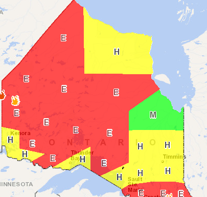
DRYDEN, Ont. — The forest fire danger rating across much of northwestern Ontario has risen to Extreme.
The Ministry of Natural Resources and Forestry fire information map published Monday morning shows an Extreme rating for areas from the international border to the far north.
Exceptions include areas close to Thunder Bay, Kenora and Fort Frances where the fire danger is listed as high.
The MNRF reported four new fires in the region as of late Sunday afternoon, including two near Pikangikum First Nation and one in the Rainy River district. All were listed as less than one hectare in size, and all were said to be human-caused.
A fourth fire was reported on an island north of Wunnumin Lake First Nation.
