THUNDER BAY – Area residents got a peek at long-term plans to rebuild a stretch of Highway 61 near Thunder Bay at a public information session Tuesday.
Planners with the Ministry of Transportation of Ontario and BT Engineering reviewed a longlist of preliminary design options for the highway and several interchanges, and took questions from the public at the virtual event.
Concerns centred around impacts to nearby landowners, secondary access to Fort William First Nation, and the accommodation of cyclists.
Public feedback can still be submitted online at the MTO’s project website, with more input opportunities to come.
The process will define a long-term improvement plan for a stretch of the highway running 9.2 kilometres south from the Thunder Bay Airport to just past Loch Lomond Road.
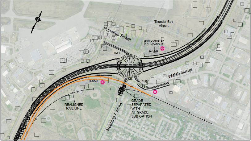
From the airport south to Chippewa Road, all options envision a freeway design with higher speeds, and the elimination of traffic lights in favour of controlled access interchanges.
South of Chippewa Road, the highway would transition to lower speeds and maintain at-grade intersections, with changes like roundabouts and road realignment on the table.
The MTO considers the stretch a “major link,” with average traffic volumes of 24,000 vehicles per day at Arthur Street and 9,000 south of Loch Lomond Road expected to grow.
Implementation of the plan remains a question mark, with no budget or construction timeline set by the province.
However, the process gives developers, the municipality, and other players certainty as they plan things like subdivisions and bridge replacements for the coming decades, said Steve Taylor, project lead with BT Engineering.
It also gives the province time to purchase property, which would be required under several design options. The impact to property owners will be weighed against factors like traffic flow, safety, social impacts, environmental issues, public input, and other factors, Taylor explained.
Those trade-offs were the subject of several questions on Tuesday.
Cindy Brown, who identified herself as an MTO employee, asked about an option that would realign 15th Side Road to connect with Riverdale Road. That could impact recent severances in the area, where houses are being built, she said.
She urged the team to develop the plan quickly to give landowners a clear picture of the area’s future.
One resident who lives on the highway near Cavar Road was told some options in the plan would result in the removal of some of her property.
“I know we need this done for sure, because there are so many new subdivisions and it is a heavy-duty traffic area,” she said.
Another resident, who also noted he worked for the MTO, asked if plans to move the CN Rail line near the airport interchange would displace green space at the nearby Westfort Playfield.
Taylor said the MTO had worked with municipalities in similar situations to find alternative locations, saying the planning process requires balancing competing priorities.
“There may be some houses that need to be purchased, there may be changes to the sports fields, but it may provide a better long-term solution for the community,” he said.
He suggested costs wouldn’t be the determining factor.
“[Cost] typically doesn’t get the dominant amount of weight,” he said. “It is a consideration, because it’s investing public money. But usually, the selection is [about finding] the right long-term solution that’s going to be there for a century, so it’s better to do it once and do it right.”
The MTO will consider eliminating the intersection at Broadway Avenue, instead extending the local road system to connect Neebing Avenue with Chippewa Road, based on feedback from Fort William First Nation.
That could bring numerous benefits, Taylor said.
“If you want to come from the rural area as a less confident driver, this would be providing a crossing of the Kaministiquia River… beside the freeway for local traffic. It could accommodate cyclists and pedestrians… It [also] provides a detour route for the freeway if there’s a closure."
The existing secondary route over the James Street Bridge can’t accommodate heavy traffic, Taylor noted.
He also presented options for potential short-term improvements at Chippewa Road, which he said could be implemented “well before” the larger plan.
Resident Frank Wilson pushed planners to include cyclists in the plans, as more people transition to active transportation in the era of climate change, including electric-assisted bikes.
He also asked if the plans were designed with climate impacts like increased flood risk in mind, which drew an uncertain answer from MTO project manager Kevin Saunders.
Taylor said climate change presents a “huge issue” for long-term infrastructure projects, noting provincial guidelines like rainfall intensity curves are changing based on climate trends and projections.
Members of the public can view design options and submit feedback at the project website. Comments submitted by Nov. 1 will be used to help refine and rank alternatives for the next stage.
A second public information centre is tentatively planned for summer of 2022.
