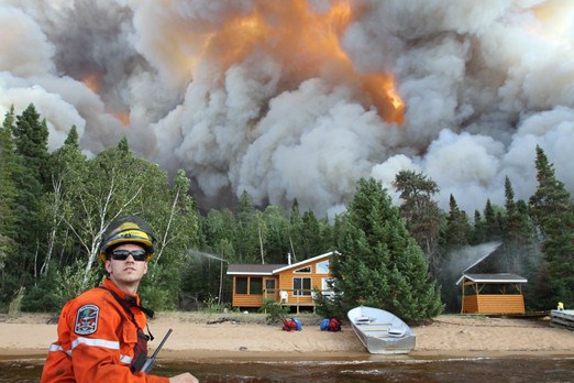
More than 4,000 people were evacuated from their homes this summer as forest fires raged a little too close to their communities.
A record was broken as those people fled from the massive fires – 629,000 hectares of Northern Ontario’s land burned – the largest area burned on one region in a single fire season.
The fires were too much for the province to handle, so Ontario called on reinforcements from across the country and even Minnesota to battle the 908 blazes that ravaged the North this year.
But would a normal snowfall for the area the previous winter, 130 centimetres instead of the 50 centimetres recorded, have dampened the destruction of those fires?
Dryness is one of several contributing factors to an intense fire season, and that could be caused by the amount of snow the area receives throughout the winter.
In 2010, Thunder Bay saw a total of just more than 50 centimetres of snow.
Local climatologist Graham Saunders measures the temperature and the snowfall in Thunder Bay twice daily.
“Typically in the past, the forest gets a head start because of the stored up moisture in the snow,” he said. “If the trend to less snow continues then that’s problematic because it’s more difficult for agriculture and more forest fires.”
In the 1970s, the city used to get an average of 225 centimetres of snow each year. In the last handful of years, the average has hovered around 130 centimetres.
“That trend is steep,” said Saunders.
Less snow not only means the possibility of forest fires, trouble for gardeners and farmers, and a poor ski season, but it also has a significant impact on area wildlife, particularly boosting the deer population.
Michael Deschamps, management biologist with the Ministry of Natural Resources, said the reduced snow accumulation in Thunder Bay over the past 10 years has been a major factor in the area’s increasing deer populations and an expansion of their range.
The spiking deer numbers in turn have caused the wolf population to rise as deer are major prey to the wolf.
But, Deschamps said wolves are generally not limited by snow depths.
“Low snow depths may give them easier access to prey, however, wolves often have an advantage with deeper snow when they can move on top of the snow where deer and moose sink in,” he said.
Lower amounts of snow can also be bad for small animals, like voles, that live under the snow in the winter and it could also result in less insulation for bear dens.
“(It) could increase the energetic costs of hibernation and thus cause the bears to emerge from the dens in poorer conditions,” Deschamps said.
While the Thunder Bay area has seen reduced snow over the past few winters, it has also seen milder temperatures.
While warmer weather is a plus for some animals – it saves them energy used to survive the harsh temperatures – it is also a sign of climate change.
“The warming is more pronounced in the Arctic and somewhat is less noticeable here,” Saunders said, adding that last winter the Arctic was five to 12 degrees warmer than normal whereas in Thunder Bay it was just a few degrees warmer.
The average temperature for Thunder Bay in the last few years for December and January are -11.6 and -14.8 respectively, according to Environment Canada.
Spokesman Geoff Coulson said there is a tendency to see fluctuations from season to season, but their climatologist have seen a trend not only in Ontario, but across the world, of some of the warmest seasons on record have occurred in the last 10 to 15 years.
“One of the big things that stood out was how warm this past month, October, was across a number of places in Northern Ontario,” he said.
“In fact, Dryden set a record for the warmest October they’ve had.”
Kenora also saw their warmest October since 1963 and Red Lake saw their highest October temperatures since 1973.
“We’re actually heading into this winter from one of the warmest Octobers in certain locations in Northern Ontario in a number of years,” Coulson said. “That’s a trend we’ve seen in at least terms of a month-by-month number.”
“Many locations have seen warmer than normal conditions fairly consistently since last spring. October was a continuation of that trend,” he added.
Thunder Bay’s long range forecast issued for November through to January call for temperatures to be in the normal range, said Coulson, adding that doesn’t mean there won’t be dips and changes on a day-to-day basis.
The forecast is also predicting another drier than normal winter for Northwestern Ontario, from Thunder Bay to Kenora.
That doesn’t bode well for next year’s forest fire season.
