The flood outlook for Thunder Bay and surrounding area is now a flood watch.
Bill Bartley, president of the Lakehead Region Conservation Area, on Friday said with up to 95 millimetres of rain expected to fall between now and Monday the public should take plenty of caution around local waterways.
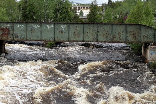
The city and surrounding communities have already absorbed up to 65 millimetres of precipitation in the past 24 hours and it’s only the good fortune of a dry winter that Thunder Bay’s rivers and lakes haven’t overflowed their banks, Bartley said.
“As you know we’ve been in a low-water situation and this has given us the opportunity to absorb what we got overnight. Saturday’s (rainfall) is going to be somewhat minimal, but on Sunday and Monday we’re looking at some more rain, in the 30 to 40-millimetre range each day, so that could cause some problems.”
With any more water falling from the sky, rivers will start cresting. And while the Kaministiquia River is normal for this time of year, it’s due to rise should the rain arrive.
“We just want to let parents and caregivers know, that while water is a great thing to watch for your young child, please tell your children to stay away from river banks. Some of them will be undercut and you could find yourself getting into the stream.”
The flood watch, issued mid-afternoon on Friday, affects Thunder Bay and several surrounding townships, including Neebing, Oliver Paipoonge, Shuniah, O’Connor, Conmee and Dorion.
Forecasters are predicting between 15 and 30 centimetres of rain on Saturday, 40 millimetres more on Sunday and 25 mil
limetres on Monday.
“Rainfall amounts may be exceeded in the event of Thunderstorms,” Bartley said.
In Thunder Bay, the Neebing-McIntryre Floodway has begun to divert flows and will likely continue to do so after the weekend, he said.
Flood watches are issued when the assessed conditions indicate the potential for flooding exists. It remains in effect until Monday and LRCA officials will continue to monitor and update it as conditions warrant.
“Fortunately we’ve had the low water conditions since last November. After this weekend, that’ll probably be history,” Bartley said.
For anyone living on or near the city’s rivers, Bartley suggested precaution as the word of the day.
“If they have anything in or around the water I would pull it back because it could crest and it could go over the banks,” he said.
“It was interesting, but we knew it was coming.”
Sign in or register
- Messages
- Post a Listing
- Your Listings
- Your Profile
- Your Subscriptions
- Your Likes
- Your Business
- Support Local News
- Payment History
Registered Users
Already have an account?
New Users
Create a free account.
