The city is fighting to keep roads clear as motorist fight to stay on the streets following one of the season’s most significant snowfalls.
City snow plows began clearing the main traffic arteries around 2 a.m. Monday. Those same plows began working on residential areas around 8 a.m., said Brad Adams, City of Thunder Bay’s manager of roads.
In terms of duration, this is the most significant snowfall city crews have dealt with this season. About 10 centimetres of snow hit the ground by Monday morning, with another five centimetres touching down in the afternoon.
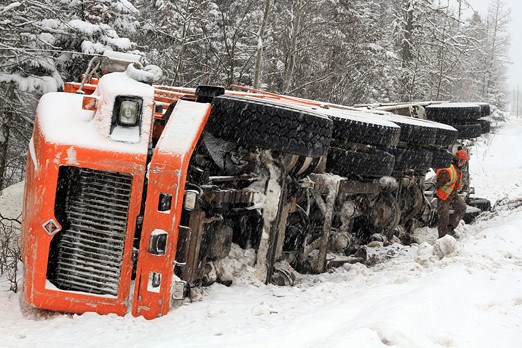
Despite the snow-clearing efforts, many motorists found themselves sliding into ditches or bumping into other drivers around the city. One incident on Mapleward Road saw a salt truck overturn into a ditch. Other similar incidents could be spotted throughout the day across the city.
“There were a number of collisions on a day like this,” Thunder Bay Police Service spokesman Chris Adams said. “This is a really good example of why we always give these public warnings about slowing down, adding more distance and really judging your driving conditions.
“There’s certainly more snow than expected, but it shouldn’t change anything. Even one centimetre of snow can cause your driving conditions to deteriorate. People should always be prepared. We live in a northern climate, we should be driving accordingly.”
Police didn’t have collision statistics available, but Chris Adams said many collision reports began coming in by 9 a.m.
Snow began falling Sunday evening, and Environment Canada spokesman Jeff Coulson said it would likely conclude sometime Monday afternoon.
“Once this system moves out of the area we are looking at clearing skies in the evening, setting up for sunny skies on Tuesday,” Coulson said during a phone interview Monday morning.
Thunder Bay isn’t getting hit as hard as some parts of the region. North Shore communities, from Terrace Bay to Wawa, are expected to get more than 20 centimetres of snow, he said.
That extra bit of snow led Environment Canada to call for snowfall warnings for communities along the North Shore.
But the story doesn’t end with the snow. Once the snow does stop falling, colder temperatures are expected to arrive.
Environment Canada’s long-range forecast shows lows of -15C, -17C and -14C for Tuesday, Wednesday and Thursday respectively. The forecast doesn’t show the area warming up for the weekend, with a low of -26C for Friday and -23C on Saturday.
“We will probably see (some snow) later in the week,” Coulson said. “But I think the real story weather wise, once the snow ends later (Monday) is going to be the cold. We will be setting up to have a relatively chilly day for Tuesday at -15C, the normal high for this time of year in Thunder Bay is -9C.
“There is some snow in the forecast for Thursday, but right now it doesn’t look like it is going to amount to much more than a few centimetres, but again it will be much colder than it should be for this time of year.”
Schools in the city remained opened despite the snow.
Sign in or register
- Messages
- Post a Listing
- Your Listings
- Your Profile
- Your Subscriptions
- Your Likes
- Your Business
- Support Local News
- Payment History
Registered Users
Already have an account?
New Users
Create a free account.
