A website is offering users the chance to examine the massive BP oil spill from a different perspective.
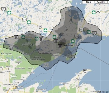
The site ifitwasmyhome.com allows users to place a diagram of the oil spill on a Google map. Punching in your hometown will bring the centre of the spill to that area and will show users how much area the spill could cover.
Using Thunder Bay as a reference point, the site shows that the spill would cover Thunder Bay, Terrace Bay, most of Lake Nipigon, Quetico Park, Grand Marais a chunk of Lake Superior and everything in between.
If the spill is placed in Lake Superior, it is able to cover more than half of the Great Lake and much of its shorelines.
The site also features streaming video of the spill and a counter that estimates the number of gallons that has spilled into the ocean.
The Gulf of Mexico oil well began leaking in April and since then U.S. President Barack Obama has called it the greatest environmental disaster in that country’s history.
The American government estimates that about 12,000-to-19,000 barrels of oil are leaking into the Gulf everyday.
Sign in or register
- Messages
- Post a Listing
- Your Listings
- Your Profile
- Your Subscriptions
- Your Likes
- Your Business
- Support Local News
- Payment History
Registered Users
Already have an account?
New Users
Create a free account.


